()
Fort San Jose
Defensive position in Umatac
Fort San Jose, built about 1805, was the third of four Spanish fortifications built in the southern village of Umatac. The fort was constructed atop a hill located on the northern side of Umatac Bay. From this location, the fort had a sweeping view of the coastline and was well positioned to defend the ships that anchored off the bay.
During the second half of the sixteenth century, Umatac Bay became an important safe-haven and supply station for Spanish galleons sailing across the Pacific Ocean during the Acapulco-Manila galleon trade (1565-1815). However, these galleons, loaded with treasures, also caught the attention of Spain’s enemies. The first English privateer to reach Guam’s waters was Thomas Cavendish in 1588, aboard the Desire. Cavendish replenished his ship with food and water supplied by Chamorros in flying proas (outrigger sailing canoes) that came to meet the ship, but he did not anchor. Later, the ill-tempered Cavendish ordered his men to spray the proas with musket fire as the islanders tried to follow his departing vessel. With the steady increase of non-Spanish ships sailing through the Pacific, fortification of the island became imperative.
From 1680 to 1810, four Spanish fortifications were built to protect the anchorage at Umatac Bay. In 1680, a battery named Nuestra Señora del Carmen was assembled on the shoreline of the bay to protect the mouth of the Salupat River where ships filled their water barrels. By 1742, British Commodore George Anson reported on the existence of Fort Santo Angel, on the northern tip of the bay. This fort was later modified in 1756. In 1805, Fort San Jose was constructed on a hill above and to the north of Santo Angel. And, by 1810, the last Umatac fortification, Fort Nuestra Señora de la Soledåd, was constructed on the southern tip of the bay.
Fort San Jose was built during the administration of Governor Vicente Blanco (1802-1806). Its construction was instigated by the 1803 inspection of its predecessor, Fort Santo Angel, by Captain Ignatio Martinez. It was determined that Santo Angel was in poor condition as a result of years of pounding surf wearing away its foundation.
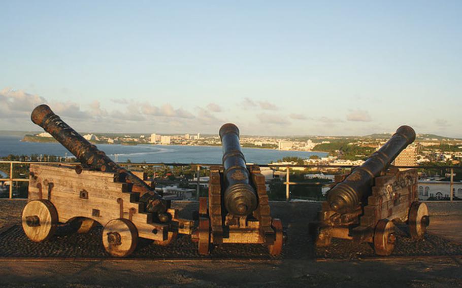
Upon this inspection, Governor Blanco ordered Fort San Jose to be constructed on the hill above the damaged Fort Santo Angel in order to strengthen the defense of the bay. In an 1805 document, Governor Blanco identified the fort by name and described that it housed five eight-caliber cannons, one six-caliber cannon, a sentry-box, and a powder magazine.
The fort was built in an oval shape, approximately forty varas, or 112 feet, above sea level. Its walls were constructed of mampostería; stone and mortar. The esplanade was level and protected with a knee-high parapet, over which the cannons were positioned to fire.
The condition of the fort steadily deteriorated over the years. The Mexican Revolution facilitated the end of the galleon trade. In 1815, the last Cavite ship returned to the Philippines, officially bringing an end to an era that lasted for 250 years. Spain no longer had the means to maintain Guam’s fortifications. In 1818, Governor José de Medinilla y Pineda reported that the construction of San Jose was poorly planned and the ground it was situated on had sunk. He also observed that the fort was not situated in an area where it could protect the bay’s channel entrance . By 1853, Governor Felipe de la Corte declared the fort to be in total ruins. Today, little remains to distinguish the area of the fort.
Fort Santa Agueda
At Apugan Hill, overlooking Hagåtña
Fort Santa Agueda, the only surviving Spanish fort in Hagåtña, sits atop Apugan Hill on the western coast of Guam. The fort, now commonly called Fort Apugan, provides a commanding view of the capital village of Hagåtña, the Philippine Sea, and the sheer northern clifflines of Oka Point and Urunao Point. The fort is also in a prime location to study the northern topography of the island with its raised limestone plateau. During the Spanish era, however, the site was developed for tactical purposes.
Built in 1800 using mampostería
The fort was built during the administration of Governor Manuel Muro (1794-1802). Construction of the fort was spurred by orders from Spain for all governors to reinforce the defensive capabilities of the empire against Britain. The fort was completed in 1800 and is named in honor of Muro’s wife, María Agueda del Camino. The fort was constructed from stone rubble, known as mampostería, which is a Chamorro construct of Spanish origin. The terreplein, a level space behind the parapet or wall, was created with a mixture of loose gravel and sandy soil. The parapet, approximately five feet tall, was built on the raised terreplein.
The fort was equipped with embrasures for ten small cannons, which were faced toward the Hagåtña Bay channel. Muro selected Apugan Hill as a fortification site to protect the low lying Governor’s Palace and Fort San Rafael, which were prone to hillside assaults. Spanish governors were concerned with the possibility of English privateers pillaging the colony or capturing vessels involved with the lucrative galleon trade.
One of the earliest historical references to the fort was written by William Haswell in 1802. Haswell, a Spanish-speaking first officer aboard the chartered American whaler, Lydia, reported seeing seven cannons and 10 men stationed at the fort. Shots were fired from the fort as a salute when Vicente Blanco, the Spanish governor who replaced Muro, first entered the church in Hagåtña.
Forts not needed after Galleon trade falls off
Throughout the 19th century Spanish governors had a difficult time maintaining Guam’s fortifications. The end of the galleon trade about 1815 – due primarily to the Mexican Revolution – brought economic hardships to Guam as supplies and finances became scarce. Spain was no longer benefiting from Mexico’s silver and the nation had incurred a tremendous war debt. In 1817 Russian commander Otto von Kotzebue, aboard the Rurik, reported that Santa Agueda had only a few guns with no powder. In 1853 Governor Felipe de la Corte reported that the fort had the capacity to house fifty pieces of artillery, but was scarcely protected except for a nine-foot railing. In 1871 Governor Louís de Ibáñez y García judged the fort to be useless and in 1887 Governor Francisco Olive y García also questioned the fort’s effectiveness.
Americans use as a signal station
During the early American era, the fort was used as a signal station for ships. In 1933 the area was cleared, a road was constructed and it was proclaimed a naval government park. In 1942, during the Second World War, the Japanese recognized the strategic location of the fort and built a gun emplacement on the site. Japanese characters can still be observed embedded in the concrete.
Currently the site belongs to the government of Guam and is maintained by the Department of Parks and Recreation. All that remains of the fort is a raised viewing platform, but the site is one of the most frequently visited parks by tourists given its unobstructed view of Guam’s scenic western coast.
Fort San Luis
Built to protect harbors
Fort San Luis was the first of three Spanish fortifications constructed to protect the anchorage at Apra Harbor. The fort was constructed on the northern shoreline of Orote Peninsula near present day Gab Gab Beach. This strategic location allowed the Spanish to defend ships that were anchored in both the harbor’s large outer section as well as its more shallow inner section.
The development of the new harbor was spurred by the increasing number of non-Spanish ships sailing through the Pacific in the early eighteenth century. Spain, wanting to deny the possibility of rival powers interfering with its Pacific trade route and missionary objectives, issued orders to strengthen Guam’s defenses. Apra Harbor was tested for depth and mapped during the administration of Governor Francisco de Cardenas Pacheco (1734-1740). In 1734, the new anchorage was opened and by 1740 most ships anchored in the harbor, as it offered ships better protection from enemy vessels and poor weather conditions than did the southern anchorages at Umatac and Merizo.
In 1737, Fort San Luis was constructed to protect the new harbor. The fort was built close to the water’s edge and protected both the inner and outer harbors. Its walls were constructed of stone and mortar with dimensions measuring forty feet long by twenty-four feet wide, with a height of thirteen feet from its base to the top of its embrasures. The cemented stone structure was built atop a bare rock foundation. In a letter addressed to the King of Spain in 1738, Pacheco reported that the fort housed six cannons: 2 ten-caliber (500-yard range), 1 eight-caliber (475-yard range), 1 six-caliber (350-yard range), and 2 four-caliber (250-yard range).
Weaknesses
Although the fort’s location was strategic in the sense that it could protect the inner and outer harbors, it did have its flaws. First, it was not sheltered from behind except for a small hill, which enemy forces could overtake by landing at alternate sites. Second, the fort had no protection on either side of it, also making it prone to ground attack from troops landing at other sites. Finally, enemy fire could cause small land slides at the rear of the fort, impeding its efficiency in returning fire.
Like other Spanish fortifications on the island, Fort San Luis changed over the decades. In 1742, British Commodore George Anson received reports that San Luis had 5 eight-caliber cannons. In 1772, Lieutenant Julien Crozet, commander of a French expedition that anchored at Apra, described the fort as having 8 twelve-caliber cannons and, by 1817, Russian commander Otto von Kotzebue reported that the condition of the fort had declined and it was no longer in use.
Today, there are no visible remains of Fort San Luis.