Travel
Hiking to Guam’s beautiful Hilaan Beach
360 Guam
July 31, 2025
(360 Guam)
Overview + Views During the Dry Season
This trail is moderately easy. It consists of walking along a beach with a very small section of walking on sharp coral. It is fully exposed to the sun for most of the way. The sights at the end are incredibly beautiful and the walk is easy enough for most people, making it a definite must-see on the island.
What To Bring: Sunscreen (this hike is totally exposed to the sun), water shoes (there are coral and rocks in the water), swimsuit, snorkel gear, sunglasses.
Directions
From Naval Base Guam;
Drive north on Marine Corps Drive for about an hour. You will pass Polaris Point, Agana, Route 6 & 7, the GPO, Home Depot & the airport, Tumon, and K-Mart. Immediately after passing the road for Micronesia Mall (Route 16), you will see a small sign for Two Lover’s Point (Puntan Dos Amantes) on your left. Turn down that road.
Turn left at the stop sign. You will see a stone marker for the entrance of Two Lover’s Point on your left, but do not turn here; keep going straight. You will drive through some twists and turns, down a hill with a view of a giant parabolic antenna, and end up at Tanguisson Beach.
Drive carefully on this dirt road and watch out for potholes. Park here at the Tanguissen Beach Park between the trees.
From north of Micronesia Mall and Tumon;
drive south on Marine Corps Drive. Once you start approaching route 16 and Micronesia Mall, look out to your right for small sign for Two Lover’s Point (Puntan Dos Amantes). Turn to the right at this sign.
Turn left at the stop sign. You will see a stone marker for the entrance of Two Lover’s Point on your left, but do not turn here; keep going straight. You will drive through some twists and turns, down a hill with a view of a giant parabolic antenna, and end up at Tanguisson Beach.
Drive carefully on this dirt road and watch out for potholes. Park here at the Tanguissen Beach Park between the trees.
Parking Park between the trees at the Tanguissen Beach Park.
Trailhead From the Tanguisson parking lot, walk down onto the beach and start in a northernly direction, which would be to your right when you are facing the ocean.
The Trail Guide From Tanguissen beach, begin your trek north, to the right.
Climb the rock steps and follow the trail beneath the trees. Soon you’ll find a fork in the road. Take the trail to the left (as shown by the couple walking to the left in the photo below) to explore an area that has been cleared, with rock piles and a cross, all surrounded by curbs of coral and rock.
Walk back to the start and take the trail to the right (you may have to step over a curb or a fallen tree) to take the trail onwards to the beach, as shown by the man to the right in the picture above.
The trail will finally take you down to the water on a coral beach with a couple rock walls. Keep walking and it will become a sandy beach. Notice the old pipes from World War II in the water.
When you walk up to a outcropping of coral wall, look to your right, up the hill and see a trail that passes by a tall palm tree. Take this path up (shown in figure A below) and around on the rock path. You’ll end up walking on the sharp coral and have to carefully climb down a few feet off the coral (shown in figure B below). This should be easy enough for kids to do.
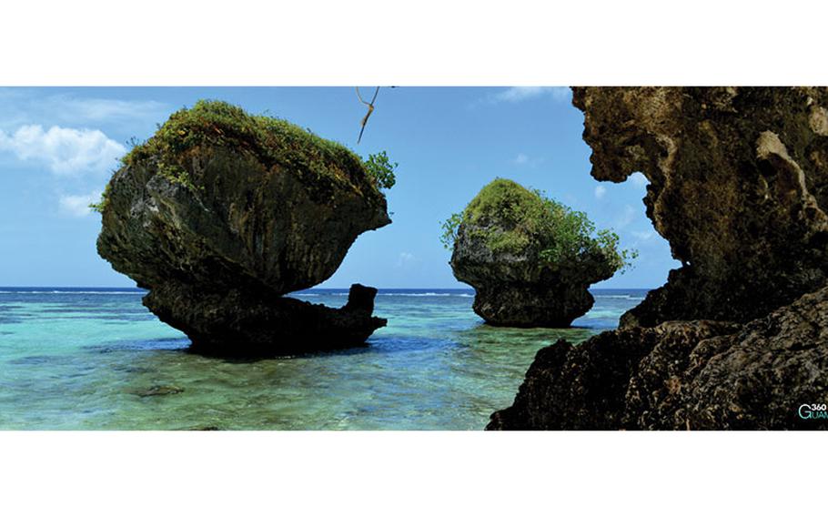
As you keep walking along the clear water you’ll see homes nestled in the greenery to the right. You’ll see the rock formations ahead. When you reach them you have arrived at Hilaan Beach. To leave, go back the way you came.
Location: Tamuning Region: North Central Difficulty: Easy Time: 30 minutes to get there, allow 1.5 hours Length: .387 of a mile Elevation Gain: 26 feet Sight: Beaches Cool Stuff: Mushroom-shaped rock formations, seashells & coral