Travel
Hiking through jungle to terrific Tarzan Falls
360 Guam
June 6, 2025
(360 Guam)
This hike can be extremely muddy, so be sure to wear clothes, socks, and shoes that you don’t mind dying a shade of red, at least temporarily. There are spectacular views, lovely spots to swim, and a natural waterside too! There are two ways to get down to the first waterfall – one easy and one a bit more adventurous.
Quick Stats Location: Santa Rita Region: Central Difficulty: Easy-medium in sunny weather (via trail route), medium while raining (via rope climb) Time: 35 – 60 minutes one way, allow 3 hours Length: 1.4 miles Elevation Gain: 300 feet down and back up Sight: Waterfalls, freshwater Cool Stuff: Secret water slide, rock climbing
Overview This walk offers beautiful views of the river, waterfalls, and Guam’s tropical foliage. It also offers some lovely places to swim. Tarzan Falls is an extremely muddy hike, and is especially flooded (resulting in hikers walking waist-deep through thick red water) after a good rain, which is the best time to see the waterfalls. Make sure to wear tennis shoes and clothes you don’t mind getting very dirty.
The are a few fairly steep hills to walk down and back up again, so keep in mind that this could be very strenuous if you have any joint issues. This hike shows you one incredible waterfall and other medium-to-small falls farther down the river (one of which can be used as a water slide!). It takes about an hour and a half to reach an extremely steep cliff, which marks the end of the trail for our purposes, where hikers turn around and go up a different hill trail to return to the start.
What To Bring: Clothes to get wet and muddy, shoes to walk in water, bug spray, food & water
Tips: Go after it has been raining for really spectacular waterfalls, but try to avoid going while it is raining. It becomes very dangerous.
Directions From the Northwest (taking Marine Corps Drive):
Drive all the way to the southern end of Marine Corps Drive.
At Naval Base Guam, turn left.
You will pass Pizza Hut on your left. At the light and the Mobil Gas Station (on your left), turn left.
Follow the road, passing Payless, until you see a poster-sign that says “Santa Rita” on it (the first left), and turn left there.
Take this road for about 20 minutes. Drive carefully as there are many potholes.
After the twists and turns and uphill driving, you will get to a level straight away with grass on the sides of the road (no longer homes). Keep your eyes peeled to the left for a patch of red dirt for parking and a large trail opening (which usually has a chain across it) where the Tarzan Falls trail begins. Another sign that you are in the right place are the endless pairs of red dirt-stained sneakers adorning the electrical lines above side of the road where cars park.
Parking Park on the red dirt to the right of the opening of the hike. You’ll know you’re in the right place based on the telephone lines overhead, the trail sign, and the chain that is across the opening to keep out cars.
Trailhead Begin the the hike by going around the chain and past the Tarzan Falls trail sign.
The Trail Guide To begin, walk along the red dirt trail to the left of the chain restricting access to the off-roading entrance. After a rainy day the path will be extremely muddy and flooded with water. The left side has less flooding, while some spots on the right side can be so flooded that you have to walk through waist-deep water. Take the trail to the left/center for two forks. You’ll start to descend downwards soon.
Next you’ll walk down three steep hills. Choose any path, they all go to the same place. The trails on the right side seem to be the least steep. A couple of the center trails (the middle of three directions) have large tire marks that can be fun to slide down, if conditions are wet enough.
At the base of this downhill walk you will reach a river that runs over flat, stone ground. This is the top of Tarzan Falls. There are two ways to get down to the base of this waterfall – an easy way and a difficult way.
Easy Option: Keep going straight across the river to find the easy trail. Find the markers among the trees and follow them down. When you reach the river, cross it by stepping on the rocks or by walking right through the water if the conditions permit. Walk up upriver, to your right, towards the falls, to enjoy the view and to go swimming. Please note that you CANNOT jump into the pool – it is not deep enough.
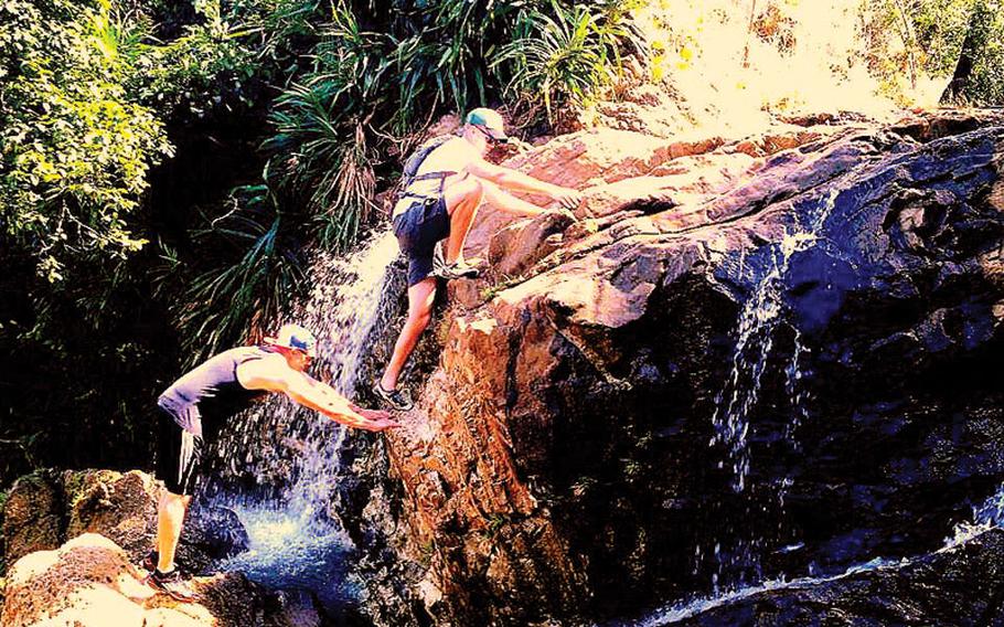
Hard Option: DO NOT attempt this version if you are not in moderate shape and are physically able. Try this way at your own risk. Standing on the stone, follow the water’s direction and turn to the right. Standing facing downstream, on top of the waterfall, very carefully find handholds and footholds to the far right side to climb down the first section of the waterfall. You will climb down to a ledge where you can rest before the rope climb down. Have fun carefully standing close to the wall to feel the water fall heavy around you.
You will find a rope to the far right (looking down) to climb down the second, and steepest, section of the falls. Take care to check the rope and the knot first to make sure they are in good condition. Hold on to the rope tightly and use your feet to find solid places to hold your weight. Shorter people have more of a challenge here.
Do not jump down at the bottom of the rope, as inviting as it may seem; Either carefully climb into the water or climb down to the left (facing the rock, back to the pool of water) where the rock creates a long, curved shelf.
Enjoy the large pool at the base of this magnificent waterfall. If it has rained recently and the waterfall is heavy, pop your head up into the little air pocket where the water falls away from the rock.
Keep walking downstream either on the trail on the left (facing downstream) or by trekking through the water. You will notice a trail that leads up the hill. This is the way out, so remember where it is for the way back
Soon you will reach a second, medium-sized waterfall. Here you can find a secret water slide. Walk across very carefully to the far right side of the waterfall (facing downstream). Be careful not to step in a deep hole near where the water starts falling down the rocks. Sit down in the spot that seems like a perfect cubby-seat and scoot your way forward until the water takes you away. Note that this only works when there is enough water to fill the below pool deep enough, and to have enough force to easily take you down the slide. Try this at your own risk and take the necessary pro cautions (like checking the depth of the pool below) to make sure you stay safe.
To keep walking downstream from here without walking through the deep water, you can walk to the left side, but be careful of the extremely slippery rocks right off this waterfall.
Keep walking downstream and find another little waterfall. Climb down very carefully. This one can be tricky because after some rain the left side is very slippery and the waterfall is overflowing with water. In the dry season, tall people can climb the dry section of this waterfall.
You will then be at the top of another very tall waterfall. You may end your hike here and sit down to enjoy a snack as you gaze out over the trees and river. This waterfall is dangerous to climb down and, although it’s possible to do, you don’t see much else once you’re down there.
When you are ready to return, turn back the way you came. After you pass by the water slide waterfall you will find a trail that leads up the hill to your right, through some trees. There may even be some trail markers to lead the way. Make sure to stay up on the trail and not follow the gully to the right. This trail stays up on the hill, so if you find yourself in a little valley, go back and find the real trail. After following this semi-steep upward climb for 5 minutes you will be reunited with the trail above the first main waterfall. From here, retrace your steps back through the shallow river, up the three sets of steep hills, back through the trails at the top (choose the center or left trails, don’t take the trail that veers off to the right), and back to your car.
The other way out is to walk all the way back until the first main waterfall is in view again. Get onto the river path on the right side of the river (facing upstream) and walk up the hill, following the markers as you go. This will take you to the top of the main waterfall where you will retrace your steps back through the shallow river, up the three sets of steep hills, back through the trails at the top (choose the center or left trails, don’t take the trail that veers off to the right), and back to your car.