(360 Guam)
People often confuse this mountain with Mount Lam Lam. In fact, the crosses we see from the highway in the Southwest are on Mount Jumullong Manglo, not Mount Lam Lam. The tallest mountain in the world uses this trail until the eleventh (XI) cross where it parts ways to the left.
Quick Stats Location: Umatac Region: Southwest Difficulty: Easy Medium Time: 30 - 40 minutes to the top, allow 2 hours Length: .675 of a mile Elevation Gain: 653 feet (trailhead at 630 feet, peak at 1,283 feet) Sight: Mountain peak views Cool Stuff: Religious significance (crosses, Virgin Mary grotto), 360º views, wildflowers, great for sunsets
Overview This trail is wide and extremely easy to see because crowds of people hike it every year for their Good Friday celebration. A new cross is carried up the mountain by followers of the Catholic religion as they reenact Jesus’ struggle during his crucifixion.
There are sections of the trail that are extremely slippery when wet due to the clay and limestone, which line the mountainside. The incline isn’t too bad; remember all levels of fitness make this hike every year.
The wildflowers are amazing and the vegetation is different in all seasons. The view shows you Cocos Island in the South, all the way up to Two Lover’s Point and Hotel Row in the West, the cliffs of the Air Force base to the North, and miles and miles of inland and coastal views to the East. Definitely worth your while!
What To Bring: Bug spray, sunscreen, water, hiking boots, flashlights (if hiking for sunset) Tips: Bring a hat as this is a fully exposed hike, use sunscreen, and spray yourself with bug spray as the shaded jungle parts are full of mosquitoes
Directions From the North (taking Marine Corps Drive):
Drive South on Marine Corps Drive until you hit the last light facing the Apra Harbor Navy base – Naval Base Guam.
Turn left here and keep heading South. You will be staying on the main road to reach your destination, for about 20 minutes, and you’ll never turn off.
You will pass downtown Agat, the Agat boat harbor, and homes along the road. The houses go away as the road twists and turns and goes up and down in elevation. After 10-15 minutes you will pass a Humatak sign on the right. Right after that is the small Sella Bay trail parking lot (a roundabout parking area under very shady trees to your right) – keep going straight.
Soon you will see a red wall to the right, with a small space parallel to the wall for cars to park. You have arrived at your destination of Cetti Bay Overlook.
Parking You will park here at the Cetti Bay Overlook car park. Park diagonal to the wall with the front right bumper towards the wall, and the back bumper facing down the street where you came.
Trailhead As you look across the street from your car, you will see a small, magazine-sized green sign slightly up the road to the right that says, “Mt. Lam Lam”. This is also the beginning to the Crosses hike. Walk across the street and begin walking just left of the sign, following the trail that immediately pivots left and up the hill.
Take the trail up this dirt path, noticing the woodland wildflowers that grow at this level. You will find your first of about 14 stations of the cross, marked roman numeral I. Turn to marvel at the view of Cetti Bay and of the Cetti Bay Overlook.
Five or ten minutes up the trail you will find some beautiful, delicate woodland trees (and may choose to take rest here), and will proceed on to the darker red dirt section of the trail. Notice how different the terrain and ecology is in all these different vegetation patches and elevations. The trees turn to a more African savannah look.
Soon you will hike through your first short jungle section (there are about four in total), where the terrain can be muddy and the sky is hidden behind the ceiling of trees and vines. These shaded jungles are where all the mosquitoes live, so try to walk through at a brisk pace.
After the overlook, turn back and keep going forward on the trail. Pass another couple short jungle sections and reach the Virgin Mary grotto to your left, tucked away in a cavern. This is a cave where Catholics come to light a candle and pray every Good Friday. There are candles, a statue of the Virgin Mary, and rosaries here in this grotto. Beware of the swarms of mosquitoes that also like to pray here as well.
Now begin your grassy meadow, slippery, wet limestone walk. (Interesting fact: the limestone here was formed before the island was uplifted out of the ocean and thus, coral grew on it.) Take care in your footing and DO NOT grab the grasses to help steady yourself without gloves as it is sword grass. Watch for holes, wet slopes, slick limestone with no traction, puddles, and slippery volcanic clay. If you have to walk back at night because you stayed too late at the sunset, this section, and the jungles are the harder sections to descend – so make sure you have a flashlight handy!
Soon after passing through this jungle you will find on of the most beautiful parts of this hike. Keep your eyes peeled for a path to your right that leads out over the valley and towards the ocean. Take this short path (to the right of a tree) to enjoy a lovely overlook of the grassy hills, the valley where you have just hiked, Cetti Bay, the endless ocean, and that beautiful open sky. Each day brings a brilliant new scenery of sky here on Guam.
At cross number 11 (roman numeral: XI), you may see the Mount Lam Lam trail to the left if the grass is well-groomed. Keep on the main trail, which veers to the right.
Take in the sights of the grassy meadows, scatters of orchids, and finally the Eastern and Northern sides of the islands through the grass on this ridge trail. You will pass a variety of ridgeline trees and will see the crosses through the arches created by vines. You have arrived!
To return to your car, go back the way you came.
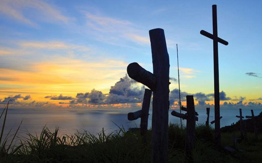
History of the Crosses At the top of Mount Jumullong Manglo (pronounced “Humuyong”), 1,283 feet high, are crosses from years of Good Friday celebrations.
Each Good Friday, before sunrise, a huge crowd of Catholic followers make the hikea to the top, stopping on the way to pray at the Stations of the Cross and lighting a candle at the Virgin Mary grotto.
On this day, Catholics will carry a heavy cross (sometimes 600 pounds) up the mountain as a symbol and reenactment of the cross Jesus carried during his crucifixion, to adorn the peak among the others.
The 14 white crosses on the walk up are marked with roman numerals and represent the Stations of The Cross – the 14 events leading up to Jesus’ crucifixion.
At Cross 11 (XI) there is a trail to the left that takes the hiker to Mount Lam Lam, the tallest mountain in the world from its base in the Mariana Trench, which is over 6 miles deep at it’s lowest point. The limestone found on Mount Lam Lam as well as Mount Jumullong Manglo is evidence that the peaks were close enough to the ocean at one point for coral to grow on them.