Travel
Exploring Guam: Trekking to Hilaan Beach and Lost Pond
360 Guam
April 5, 2025
(360 Guam)
Quick Stats Location: Tumon Region: West Central Difficulty: Easy Length: 3 Hours Gain: 40 feet up and down Sight: Beach & Pond Cool Stuff: Tons of shells and coral on the beach, mushroom-shaped rock formations, Shark’s Hole snorkeling, and a secret pond
Tips: Fully exposed so bring sunscreen! Definitely a swimming hike so bring a swimsuit! And remember, it’s a loooong walk to the pond, so bring a snack and water!
Directions: From the Big Navy Base in Santa Rita, drive North on Marine Corps Drive for about an hour. You will pass Polaris Point, Agana, Route 6 & 7, the GPO, Home Depot & the airport, Tumon, and K-Mart. Immediately after passing the road for Micronesia Mall (Route 16), you will see a small sign for Two Lover’s Point (Puntan Dos Amantes) on your left. Turn down that road.
Turn left at the stop sign. You will see a stone marker for the entrance of Two Lover’s Point on your left, but do not turn here; keep going straight. You will drive through some twists and turns, down a hill with a view of a giant parabolic antenna, and end up at Tanguissen Beach.
You may carefully (watch for potholes!) park here at this beach park, or turn right at the small dirt road and off-road it until you must park in the grass to avoid driving through private property. If you start at the actual beach park (where most of the parking is) you will see everything shown here. If you start after off-roading, you will begin at the mushroom-shaped rock formations and shave at least 30 minutes off your hike.
Walk down the trail to the beach and start the beach walk in a Northern direction (to the right).
To Begin (from Tanguissen Beach parking):
This beautiful hike shows you the crystal blue waters that everyone imagines when they think of a tropical island paradise.
The first lagoon, looking back from whence we came:
You walk through an interesting human-made rock pile in a thicket of trees at the beginning of this trail.
Some old pipes from WWII
Lagoon 2:
You’ll find the most amazing shells and pure white coral. You can touch, but please leave them there where they belong.
You’ll pass some hidden, little, natural-living homes with meadows for yards and the sparkling ocean for views.
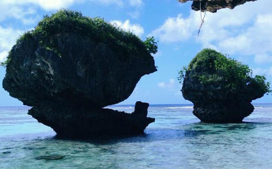
You will come upon some huge, natural rock formations in the shape of giant mushrooms with beautiful greenery resting atop.
Walk AROUND this little outcropping into the ocean. We tried to climb through the coral: no bueno!
Lagoon 3:
At the far end of lagoon 3:
Be sure to take a break and have some fresh coconut meat & water. Be careful if you use a machete!
Lagoon 4:
On this easy, flat beach walk you will walk through 3 large lagoons, you may see some divers in the various bays, the last being most popular for the “Shark’s Hole” in the middle, clear white sand easily seen through the translucent water, forming a circle where the coral was destroyed from missile fire.
Make sure to use this map to find the Lost Pond without getting lost in the jungle. We sure got lost and had hundreds of scratches and mosquito bites to show for it.
The Lost Pond, in all it’s green algae glory: