()
Editor’s note: The U.S. territory of Guam is comprised of 19 villages, many with their own distinct character, history and points of interest. Stripes Guam and Guampedia have joined forces to present this weekly feature on each of them in the hopes that it will help our readers get out – and get to know – our gracious hosts. To learn more about Guam’s people, history, culture and places, visit: guampedia.com
The village derives its name from the word uma, which means to carry something on the back or a heavy load on the shoulders.
(Map by Stripes Guam)
Village history
The history of Umatac is among the most rich of all the villages of Guam, especially during the Spanish era. Among other distinctions, Umatac is the home to Fouha Bay in which a rock called “Fouha” Rock sits. The ancient Chamorros believed this rock to be the resting place of a goddess called Fu’una who, with her brother Puntan, is credited with creating the world and people. The rock is also called Creation Point.
The pre-contact Chamorros made a pilgrimage to the rock every year to pay homage to Fu’una and to have their rice blessed to be used to cure people according to Spanish accounts. Umatac is perhaps most famous for being the site, by long oral tradition among the Chamorros, Ferdinand Magellan first landed on Guam. Although other theories about Magellan’s landing site have arisen, the residents of Umatac still proudly celebrate Discovery Day every March 21st with a re-enactment of the 1521 landing.
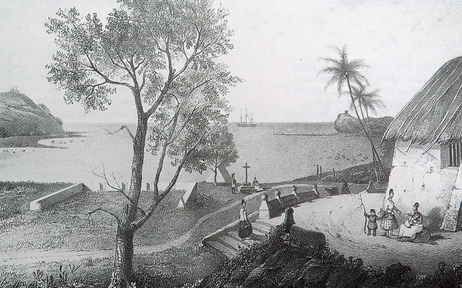
The next landing by Europeans on Guam, that of Miguel Lopez de Legazpi, forty-four years later in 1565, was indisputably at Umatac. Legazpi anchored at Umatac Bay for thirteen days and formally claimed Guam for Spain, and during his stay, a Catholic mass was celebrated in a large cruciform canoe house by the bay.
By the time of Legazpi’s visit, Umatac was already a Chamorro coastal settlement that included a large communal house raised on latte stones, so spacious it could accommodate 200 people along with large canoes, as described by the Europeans. There were also other low houses in which the Chamorros cooked and roasted food.
Umatac was the chief port for the Spanish during the early galleon days, when it was visited annually by a galleon from Aculpulco, usually in May or June. In late 1680, a Spanish settlement was established at Umatac for the first time to serve the galleons, along with a supply ship that stopped on Guam from Cavite in the Philippines, usually in August or September. The supply ship brought necessities such as soap, flour, tools, metal, animals and seeds. The galleon also brought supplies, but mainly Spanish money of Mexican silver to pay soldiers and mission personnel.
These visits were so important that the Spanish governor transferred his residence from Hagåtña to Umatac when the ships were expected. Governor Damian de Esplana built the governor’s palacio, or palace, surrounded by a presidio compound in Umatac in 1690. After the supplies were unloaded from the ships, they were transported by boat from Umatac around Orote Point to Hagåtña since no road existed between the two towns.
The Spanish attempted to link Umatac and Hagåtña with a monumental road project with the help of Filipino workers, but the road was never completed. Remnants of the project are historical sites today, including stone bridges in Umatac, Sella Bay and Agat.
The view of Humåtak Bay as seen from a section of the shore battery, Santa Barbara. Fort Soledåd, is seen on the left, with Fort Santo Angel on the opposite side. Not shown, is Fort San Jose, built on a hill beside Santo Angel. (Photo by Micronesian Area Research Center (MARC))
Historical Points of Interest
Fouha Bay/ Creation Point Umatac is the home to Fouha Bay in which “Fouha Rock” sits. The ancient Chamorros believed this rock to be the resting place of a goddess called Fu’uña who, with her brother Puntan, created the world and people.
F.Q. Sanchez Elementary School Francisco Quinata Sanchez Elementary School, more commonly referred to as F.Q. Sanchez Elementary, is one of twenty-five public elementary schools on Guam. It was named in honor of Sanchez who was an twentieth century pioneering educator and politician of Guam.
Because of its small student population, lawmakers proposed closing the school and sending its students to Merizo Martyrs Elementary School in the neighboring southern village. Umatac residents, however, strongly opposed this move.
In 1998, the school was listed in both the Guam and the National registers of historic places. It was constructed in 1953 by world-renown architect Richard Nuetra who also designed the Guam Government House.
Guam Veteran’s Memorial The park overlooks the hillsides of Umatac and is dedicated to the seventy-four Chamorro men listed on a plaque at the site who died in the Vietnam War. The park was developed by the Guam Women’s Club in 1971 and is a popular stop for tourists. A special Mass is held at the site each Memorial Day.
San Dionisio Church The church of San Dionisio was constructed of wood with a palm thatched roof and dedicated in 1681. It was later burned in 1684 by those Chamorros who opposed the Spanish, rebuilt again of wood, and destroyed again by a typhoon in 1693. It was rebuilt in 1694 of coral masonry.
By 1690, after two European disease epidemics killed a large number of Chamorros, Umatac was the largest of five parishes on Guam, with 700 people. In the early 1700s, Rota, Guam’s neighbor island to the north, was at times administered together with Umatac by the church, resulting in close ties between Chamorros in those two parishes.
In 1849 a massive earthquake on Guam demolished many buildings including the governor’s palacio, the San Dionisio Church and the convento (the priests’ residence). Only the church was rebuilt, of wood and that structure was destroyed in the severe earthquake of 1902 that also crumbled part of the Dulce Nombre de Maria church in Hagåtña. The San Dionisio church would not be completely rebuilt until 1939 at a new location, where it still stands.
The Spanish masonry ruins of the old San Dionisio Church, which are located within fifty yards of the current church, are marked by a plaque, and are on the National Register of Historic Places.
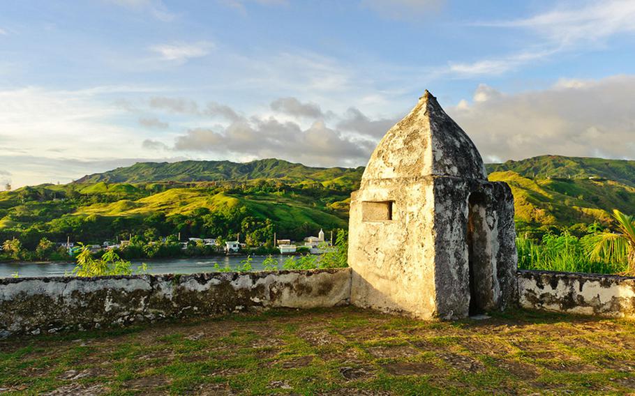
Spanish Forts From 1680 until 1810, four forts were built by the Spanish around Umatac Bay to protect the important harbor from pirates and privateers: Fort San Jose, Fort Santo Angel, Bateria de Nuestra Senora Del Carmen and Fort Nuestra Senora de la Soledad. Fort Soledad is perhaps the most famous and is now a park site often visited by tourists. It is of the most recent construction, and while it has crumbled from weather, treasure hunters and World War II over the years, much of the fort remains intact.
Umatac Pride Outdoor Library This library is not a building where you may expect to enter through a door, see windows, nor be covered by roof. This library is best described as a large, highly decorative, cement bookshelf.
This small monument-like structure, built in October 1933, served as a place where villagers could exchange books. It was built under the direction of early twentieth-century education pioneer and politician Francisco Quinta Sanchez, a resident of the southern village.
Located near the modern-day San Dionisio Catholic Church, the structure sits right next to the village’s main road, and visitors can see it as they drive slowly through the narrow Umatac road. With its walls partially crumbled, it now serves as another proud reminder of Umatac’s historic past.
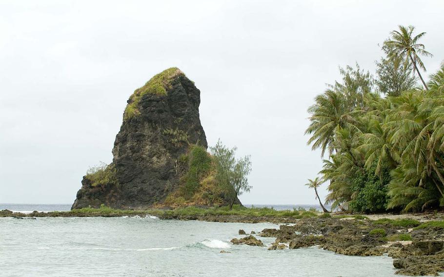
Fouha Rock. (Guampedia)
This village at a glance
Population: As of the 2000 Census, the population was 887, which is ten fewer residents than in the 1990 Census.
Village officials: Johnny A. Quinata, Mayor, 2013-Present; Daniel Q. Sanchez, Mayor, 2005-2012; Tony A. Quinata, Mayor, 2001-2005 ; Jesus A. Aquiningoc, Mayor, 1997-2001 ; Jose T. Quinata, Mayor, 1992-1997; Dean Q. Sanchez, Acting Mayor, 1991-1992 ; Albert T. Topasna, Commissioner/Mayor, 1989-1991; Cecilia Q. Morrison, Commissioner, 1985-1989; Albert T. Topasna, Commissioner, 1969-1985; Jesus T. Quinata, Commissioner, 1961-1969; Jesus S. Quinata, Commissioner, 1952-1961; Gregorio M. Camacho, (no title or dates provided); Helarion Quinata, Commissioner, (no dates provided); Agustin Quinata, Commissioner, (no dates provided); Jose Gofigan, Commissioner, (no dates provided) – courtesy of Konsehelon Mahot Guåhan/the Mayor’s Council of Guam.
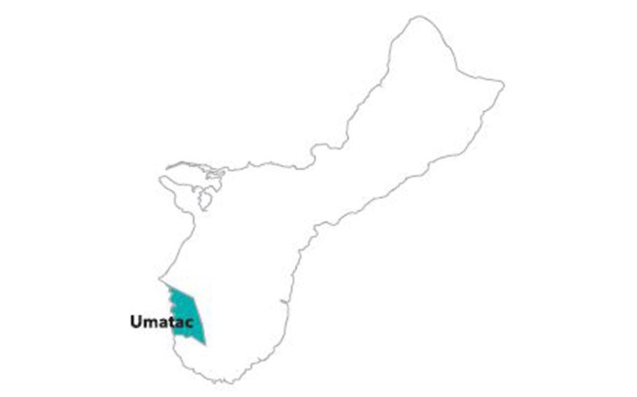
Village description: The small village of Umatac is located in southern Guam along Umatac Bay. The community of Umatac is relatively smaller than others on Guam and made up of a handful of residents, many of whom are related to each other.
Interspersed between old houses that sit along the bay’s shoreline are ruins that have become prominent reminders of the Spanish colonial era in the village. Plaques are placed throughout the village that describe the Spanish era to visitors. Remains of the Spanish times include the former Spanish governor’s residence, the site of the old San Dionisio church and several Spanish forts and a battery.
A bumpy two-lane road runs through the center of the village, and visitors coming down into Umatac from the steep hills in the north will first notice stones placed into a hillside in the shape of the island of Guam, welcoming them to the village. A couple of small stores and the San Dionisio Church, built at its current location in 1939, sit along the road.
The road, with houses built in the first half of the last century, then opens up into a spectacular view of the bay before coming to a small park with a children’s playground built by IT&E in the 1990s. Adjacent to the park is the mayor’s office, right on the beach, with perhaps the best view of any mayor’s office on Guam.
At the center of the bay is an obelisk monument to Ferdinand Magellan’s landing in 1521, bearing the inscription, “Magellan landed here.” The bay is also home to some of the island’s best surfing.
The road then crosses the Umatac Bridge, constructed with towers reminiscent of London Bridge. The bridge dates not back to the Spanish times, as visitors often assume, but to the 1980s under the helm of Governor Ricardo J. Bordallo.
After the bridge, the road runs uphill, where visitors can turn off into a small park to see the ruins of Fort Nuestra Senora de la Soledad (commonly referred to as Fort Soledad), constructed to protect the bay from pirates and other European explorers. South of Umatac is the village of Merizo.
North of the main village and within Umatac’s boundaries is an overlook to Ceti Bay, a beautiful secluded beach that can only be reached by hiking or sailing.
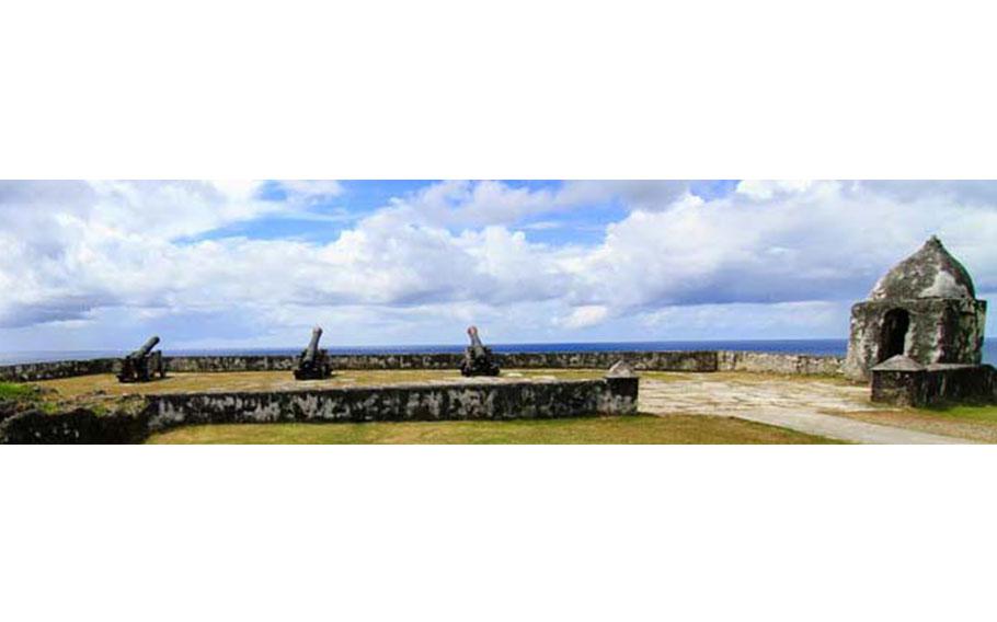
Fort Nuestra de la Soledad. (Photo by Guampedia)