(Cetti Falls)
This difficult hike rewards the hiker with pools of freshwater full of fish that will swim all around you and beautiful waterfalls that cascade for 500 feet. There is also an optional river walk to Cetti Bay, which is totally uninhabited except for some makeshift shelters in a boonie dog camp. You can even make a loop to see the latte stones and Spanish bridge & oven in Sella Bay and have much easier, although longer, path back up to the highway.
Quick Stats
Location: Umatac Region: Southwest Difficulty: Difficult [Medium when using the Sella Bay trail (SBT)] Time: Allow 3 – 4 hours [5 – 6 hours via SBT] Length: 1.2 miles [4.5 miles via SBT] Elevation Gain: 500 feet up & down [440 feet via SBT] Sight: Waterfalls, Freshwater, Beaches + 1hr (optional) Cool Stuff: Rock climbing (rope climbing), natural pools, uninhabited beach
Overview

(Cetti Falls)
This trail is difficult. Read the trail guide carefully before you go to make sure that you can handle the angle of descent and ascent, slippery surfaces, and fitness that this hike requires.
What To Bring: Shoes with good traction for hiking, gloves (the sword grass is serious business on this one), long pants and long sleeve shirt option (to avoid mosquito bites and sword grass cuts), insect repellant, head lamps (in case it falls dark or weather conditions force you to use the Sella Bay trail route), map for emergencies, food & water.
Tips: Try to avoid being caught down here during a rainstorm if you plan to use the rope climb or retrace your steps to leave. This is a difficult hike even without rain and adding rain makes it extremely difficult. If it rains we suggest you leave via the Sella Bay route. We will explain how to leave that way here, but for more information look at our Sella Bay page. Full instructions on how to get to the falls and leave via the Sella Bay route can be found here.
Directions + Trail Map
From the North: Drive south on Marine Corps Drive until you hit the light at the main Navy base in Santa Rita.
Turn left at the light and continue south passing downtown Agat, the Agat boat harbor, and Agat neighborhoods of houses along the road. Soon the drive will start going uphill, the houses will go away, and the road will begin twisting and turning.
After about 10 minutes you will pass a shady round-a-bout park (Sella Bay Trail) then find a long red wall to the right 2 minutes later, with a small area along the wall to park your car – Cetti Bay Overlook.
Parking

(parking)
Park here diagonally, pointing slightly left of, but towards, the wall, the back of your car pointing down the hill where you came, as seen in the picture.
Trailhead
To the right of the wall of Cetti Bay Overlook there is an opening in the brush directly behind a telephone poll. The opening between the brush to the bare line of a dirt trail is obvious enough, however, the steepness of the hill looks too steep (about a 25 degree angle) to be the trail. This is the way to Cetti Falls.
Trail Guide
The beginning of this trail is at about a 25 degree angle for about 40 feet. Carefully make your way down this extremely steep, lose dirt trail, using trees for footing and handholds wherever possible. You make try hunkering down to slide a bit. Do not hold onto the grass if you do not have gloves on! It is swordgrass and will slice you up!
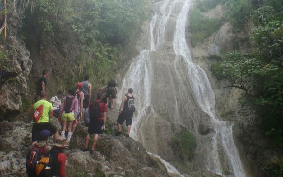
At the bottom of the 40-foot drop of dirt trail you will find more slippery, hard to traverse incline. It will take you straight down and eventually to the left. At each new section of hiking, look around for the easiest traverse possible. You should never be rock climbing down cliffs, only traversing steep rock-hills. Find the smooth, flowing rock formations or riverbeds to walk down. Stay together with your hiking partner(s) in case someone needs help. During this section there are some beautiful views of the falls to your left. You may catch some people climbing up the fells with the rope if you’re lucky, so definitely stop and enjoy.
After this section, you will find a rope assist. Use this as you hike down steep inclines and finally through a sword grass forest. Once again DO NOT hold onto this grass without gloves.
At the base of the two ropes is the river. To the left are Cetti Falls. To the right are Cetti Bay, Sella Bay, the Spanish Bridge & Oven, and the Sella Bay Trail.
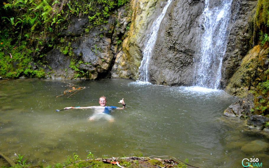
To Cetti Falls: Turn to your left and start hiking up the river. When the river is too deep, carefully use the surrounding rocks to traverse (if you have gear that shouldn’t get wet). Be careful as the rocks baby waterfalls are extremely slippery, decomposing brush will not hold your weight, and some pockets of riverbed are mushy, slippery silt. After about 15 minutes you will find the bottom section of Cetti Falls. You may take time out here to swim, take pictures, and eat your lunch.
(Cetti Falls)
To Hike Out: There are three ways to leave the bottom section of Cetti Falls.
The Most Difficult Route + More Falls: The hardest route, and the way to see the upper two tiers of Cetti Falls, is to start your climb to the right of the waterfall where the rope is. Take care to keep hold of the rope to avoid any fatal accidents. This is a difficult route for even well-experienced hikers, so please take care in your decision-making. From this route you will pass six upstream waterfalls and have a wonderful view of the valley below. Once you reach the road at the top, turn left and walk a short distance to your car. This part should take about 30 – 40 minutes.
The Difficult Route: The second hardest exit route is to go back the way you came. Walk back downstream to the place where the rope/hill climb begins to your right. You may decide to keep going past the rope climb to see Cetti Bay before you leave. This is about a 35-minute walk from the rope to the bay. (See “To Cetti Bay” below) Climb up using the rope as an aide. Hike up the smooth rock, riverbeds, and steep dirt path, using tree roots as footholds and tree trunks as handholds wherever possible. Arrive at your car.
Notice: If weather conditions (like heavy rainfall) make this route too dangerous or if you are not in the condition to climb up the steep falls, we suggest you take the easier Cetti Bay to Sella Bay Trail exit route.
To Cetti Bay: You can either follow the river (skipping across a few times where the river makes a curve so that it’s parallel with itself) or find the trail markers and take the trail. The trail is easier and faster than the river walk. It takes about 35 to 40 minutes to reach the bay from the rope climb area. Cetti Bay (at the time this was written) is completely vacant and untouched except for the small, abandoned area of makeshift tents with a common area created by Cetti Bay Tours. It is now a village for bonnie dogs who, although bark a lot, are not aggressive and mostly stay by their shelters. A nice pup might decide she wants to hang out with you for the rest of your journey. The bay has great views of large powerful waves, with beaches switching from rock and shell to sandy.
To take the difficult yet shorter exit route, return back the way you came and follow the trail markers or river back to the rope/hill climb. (See “The Difficult Route” above). For the easier route, keep going onward to Sella Bay.
Alternate Route Out: Sella Bay Trail

(bay)
The Medium Route + Sella Bay & Spanish Bridge: From Cetti Bay (looking out into the ocean) turn right and walk to the end of the Bay. Keep walking, passing a few interesting stretches of beach. You will traverse tree roots with trees stretching into the ocean, pebble beaches, large rock beaches, sandy beaches, and stretches of coral, dirt grass, and trees.
Finally, after passing a large rock formation jutting out of the shallow ocean, you will reach the last large bay. You will see that cliffs permit you from passing beyond this bay, looking across the water to the far right. Walk along the beach of Sella Bay until you spot the two-arched Spanish Bridge. (For more historical information about this culturally significant place, and to find out what there is to do and see here, click here for the Sella Bay hike page.)
After you have taken some pictures and taken in the beauty of the ruins, start your hike out behind and to the left of the bridge. You should find a trail marker to know you are going the right way (the spaces between the trees in the forest can be a little confusing and look like a trail at first). The trail should become very clear fairly soon. It’s nice and wide and meanders up the hills at a mild incline. You will leave the palm forest and walk up to smooth dirt and rock trails through hilly meadows, offering beautiful views of this valley and the surrounding green hills. You will descend the hills and cross the river a couple times, and get to ascend the hill all over again.
After about 30 minutes of hiking, you will begin the slightly more grueling last leg of the hike. The incline becomes more of a workout through a forest of woodland trees. At this point you are extremely close to your finish point (about 10 minutes) and you may begin to hear cars drive by. You will reach the summit at the parking roundabout, shaded by trees. You may want to take a water break here.
From the Sella Bay Trail park (if you have parked at the Cetti Bay Overlook), you will walk 1 mile South (to your right) back to your car. This section of the road has 4 – 5 twists and turns and has a medium incline. The highway walk should take about 25-30 minutes.