()
Editor’s note: The U.S. territory of Guam is comprised of 19 villages, many with their own distinct character, history and points of interest. Stripes Guam and Guampedia have joined forces to present this weekly feature on each of them in the hopes that it will help our readers get out – and get to know – our gracious hosts. To learn more about Guam’s people, history, culture and places, visit: guampedia.com.
Mangilao derives its name from the word ilao, which means to look for something. In the past, hunters and fishermen would go to Mangilao to search for crabs, deer, wild pigs, and fish.
Village history
The village of Mangilao today is fairly new, but the area has ancient sites that date back more than a thousand years. The district of Pagat, located on Route 15 (also commonly referred to as the back road to Andersen), was once an ancient Chamorro village. Pagat is one of the most scenic areas on the island, with breathtaking cliff lines that overlook the Pacific Ocean, and jungle trails that lead to freshwater caves and ancient latte.
Originally, Pagat was thought to have been occupied during the later part of the Ancient Guam Period or early in the Spanish Period in the late seventeenth century. Because of the areas limited accessibility, it was theorized that the first inhabitants had fled from Spanish rule, but the discovery of a certain type of pottery found there in the 1980s has proven to be typical of an earlier settlement, perhaps just more than a thousand years ago.
Mangilao lacks a natural water source, therefore, it was not until the late 1920s that the area would be repopulated after water wells, a school, and a road were built. People who owned ranches in Mangilao farmed there during the day and, at night, would return to their homes in Hagåtña. In the 1920s, Naval Governor Henry B. Price launched a vigorous “back-to-the-soil movement” to convince Chamorros to develop their agriculture and become self-sufficient. Part of his program was the concentration of farms in a given section.
The Mangilao-Barrigada area was chosen because of its rolling plateaus and proximity to the island’s capital, Hagåtña. To encourage people to live on their farms and produce more, Price built a road into the area and then the Mangilao School in 1926. He ordered families to send their children to the school, so they would have to live in Mangilao during the week and in their Hagåtña homes only during the weekend. Price ordered that an agriculture department and a dairy factory be built in the village.
After World War II, Mangilao continued to be Guam’s main farming area. Some of the village’s major crops included tapioca, cassava, corn, mongo beans, tomatoes, peppers and other beans. Many people paid for their homes by selling these crops to a new population of people that moved to Mangilao – construction workers. The village housed thousands of construction workers employed by the military who lived there during the post-war rebuilding boom. Roads and houses were built to accommodate the workers, and grocery stores began to line the village’s main road.
Although Mangilao quickly developed into a prominent village, it was not fully recognized as one at that time. Until the 1950s, Mangilao fell under the municipality of Barrigada. Jesus Pereira, who worked for the Barrigada commissioner and supervised the Mangilao area, believed the village deserved to stand on its own. At the time, he said Mangilao did not receive a fair portion of Barrigada’s budget and needed a separate budget and its own leadership. He submitted a request and Mangilao became a municipality of its own.
Pereira became the first elected commissioner in 1952 and served the village until 1968. During his tenure as mayor, Pereira saw Mangilao transform into what it is today – a growing town with the island’s only university and community college, several government agencies, public and private schools, non-profit organizations, businesses and the island’s prison and youth detention facility.
Points of interest
Historical
Marbo Cave Marbo Cave is a freshwater coastal cave. The spring was used to supply fresh water by the Japanese administration until 1944 and then by the U.S. Army until 1950. The cement foundation in front of the spring supported a large pump to bring up water from the spring.
Pagat Cave Located on the eastern side of Guam along the coastline, Pagat Cave is located in a sinkhole at the bottom of a cliff and contains a deep freshwater pool.
Recreational
Eagle Field
This recreational and sports field is located along Route 15. It was recently renovated for youth football leagues. Private skydiving companies also use the area as a landing site.
Onward Mangilao Golf Club This Mangilao golf course is located on the central eastern coastline of Guam. It offers 6,904 yards of scenic landscape for each of its 18-golf holes. It was originally opened in April 1992.
Thousand Steps This set of concrete steps, which actually number closer to 150 very steep steps, provides public access to the beach at the Mangilao Golf Club. Visitors can see a panoramic view of the Pacific Ocean along Guam’s eastern coast or a spectacular sunset.
Captain H.B. Price Elementary School More commonly known by the shorter name of Price Elementary School, this school is part of the Guam Public School System and houses grades Kindergarten through grade five. The school was opened in 1958. It was named after Price who was a former naval governor of the island in the 1920s who pushed for agricultural development in the area at the time.
George Washington High School Commonly referred to as G.W., this high school is one of four high schools within the Guam Public School System. G.W. was established in 1936 in Hagåtña (to replace the Seaton Schroeder Junior High School) and is the oldest public high school on Guam. Its first graduating class was in 1940. In 1945 it was moved from the capital to Sinajana and then to Mongmong in 1952. It was rebuilt in Mangilao in 1965 and remains in this present location.
Guam Community College Initially established as Guam Vocational Technical High School, Guam Community College—a public vocational educational institution—was created in 1977 by Public Law 14-77. The legislation was aimed at strengthening and consolidating vocational education on the island. GCC has offered secondary and post-secondary vocational programs, adult and continuing education, community education, and short-term specialized training programs. An Act of Congress in 1946 and 1963 and subsequent amendments designated the college as the State Board of Control for vocational education. Today GCC offers more than fifty courses of study that are job related. Additionally, the college offers courses of study to prepare its students to transfer to four-year colleges and universities.
KGTF-TV Public Television Station KGTF-TV, Guam’s first and only public broadcasting television station, went on the air for the first time on October 30, 1970. The station was initially funded by a federal grant from the Department of Health, Education and Welfare and the Government of Guam. KGTF established its offices, tower, and transmitter in Mangilao where it continues to operate today. An executive order created the Guam Telecommunications Commission, which enables KGTF to be licensed from the Federal Communications Commission. In 1974 the 12th Guam Legislature made a public law to create a nonprofit, public corporation to operate KGTF creating the Guam Education Telecommunications Corporation.
KGTF works closely with Guam’s educational institutions and the local government to raise the standards in education providing outreach activities, workshops, and training sessions to parents, caregivers, and educators of young children.
Pacific Bible College Established in 1991 on Guam, this educational institution offers Associate of Arts (AA) degrees, and a Bachelor of Arts (BA) degrees with focus on Christian and Biblical studies.
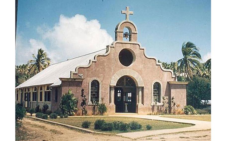
Santa Teresita Church Mangilao’s Catholic church, established in 1951, was redesigned from its former Spanish missionary style to its new architectural design and rebuilt on a lot adjacent to the former church building after being destroyed by Supertyphoon Pongsona in December 2002.
Sisters of Mercy Convent The Mercy convent opened in 1951 in Tai, Mangilao as a second convent to accommodate the growing number of sisters and novices. The first convent was in the capital city of Hagåtña.
United Methodist Church Methodist church members received a loan from the United Methodist Development fund in 1996 to build this church on Route 15 in Mangilao. The congregation was initiated on Guam in 1971.
University of Guam In June 1952 the Government of Guam established the Territorial College of Guam as a two-year teacher training school in the village of Mongmong under the Department of Education. In 1960 the college moved to its present location along the cliffline in Mangilao and by that time had expanded the academic programs, faculty and staff to meet the needs of increasing enrollment. Administrative control over the college was transferred in 1963 from the Department of Education to a five-member Board of Regents.
The college was accredited as a four-year, degree granting institution that same year and again in 1965. After gaining the maximum five-year accreditation period, the college was renamed the University of Guam by an act of the Guam Legislature. An Act of the United States Congress on June 22, 1972 designated the university as a land-grant institution. The university later gained Administrative Autonomy with the enactment of Public Law 13-194, “The Higher Education Act” in 1976 establishing it as a non-membership, non-profit corporation under the control of a nine-member Board of Regents appointed by the Governor of Guam with the advice and consent of the Legislature. The University of Guam is recognized today as the major institution of higher learning in the Western Pacific.
This village at a glance
• Population: According to the US Census, there were 15,191 people living in Mangilao.
• Village officials: Allan Ungacta, Mayor, 2017-Present; Nonito C. Blas, Commissioner/Mayor, 1987-2016; Nicolas D. Francisco, Commissioner, 1973-1987; Jesus D.L.R. Santos, Commissioner, 1969-1973; Jesus T. Pereira, Commissioner, 1952-1969; Manuel T. Sablan, Commissioner, 1950-1952; Francisco P. Pangelinan, Commissioner, 1933-1944; Thomas Duenas, Vice Mayor, 2017-Present.(courtesy of Konsehelon Mahot Guåhan/the Mayor’s Council of Guam.)
• Village description: The village of Mangilao is located in central Guam. It lies between the villages of Barrigada and Chalan Pago. The village also branches off into subdivisions bordering Dededo and Yigo. These subdivisions include Latte Heights, Latte Plantation, Sunrise Villa, Banyan Heights, and lower and upper Pagat. The village has been called “Guam’s capital of education” because both the University of Guam and the Guam Community College are located there.
Several other government agencies are also located in Mangilao, including the Department of Public Health and Social Services, the Department of Agriculture, the Department of Corrections, the Department of Youth Affairs and several schools. Many island residents work in Mangilao and have moved to the area to be closer to work. About 6,000 people who do not live in Mangilao come to the village for work during the week.